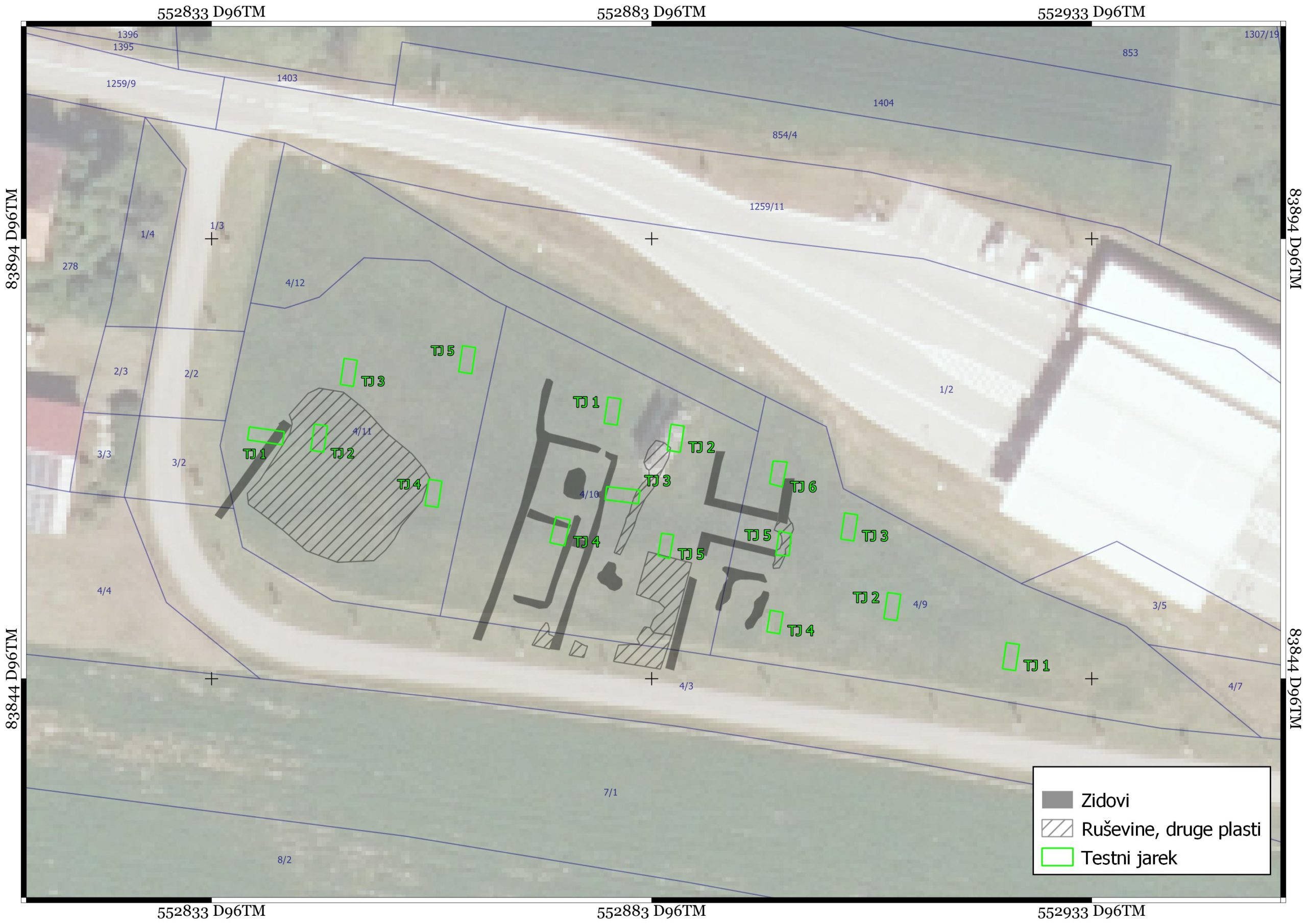
The northern part of the hamlet of Rigonce is situated on slightly higher ground surrounded by palaeo-structures, which probably enclosed (and therefore somewhat protected) a small Roman settlement (Lat. vicus) before the regulation. Prehistoric and Roman finds have been known in the past in Rigonce, and the existence of the settlement is already indicated by the very toponym of this slightly elevated plateau, i.e. Gradišnica.
Text by Gašper Rutar and Miha Murko


The northern part of the hamlet of Rigonce lies on slightly higher ground surrounded by palaeo-structures, which probably enclosed (and consequently somewhat protected) a small Roman settlement (Lat. vicus). In Rigonce prehistoric and Roman finds have been known in the past, and the existence of the settlement is indicated by the very toponym of this slightly raised plateau, i.e. Gradisnica.
Cultural heritage unit Rigonce - Archaeological site Gradišnica (EID 1-10785) comprises the northern part of the settlement of Rigonce. During excavations in 1992, three Roman wells were discovered in an abandoned sand pit, masonry structures in the eastern part of the village, and surface finds dating from the middle of the 2nd, 3rd and 4th centuries. In the western part of the village (glacier Wide), aerial photographs revealed traces of four structures, and field inspections confirmed their existence. Investigations to the south of the glacier Gradisnica, on plots 5, 24 and 28, all of Rigonce, only recent deposits over natural colluvial and alluvial layers were found (Bavec, Predan 2008), while on plot 8/4, Rigonce, on the eastern part of the glacier GradisnicaIn 2014, remains from the Roman period and individual pottery fragments from the prehistoric and modern periods were discovered in the area of the construction of the Dobova-FTHH Gabrje route and the construction of the fibre optic network in Rigonce (Mason, Arh, Mulh 2020, 26).
All these traces map for the time being the possible extent of the settlement on the raised plateau in the former Sotla river basin.
Geophysical surveys have revealed the remains of a larger structure, 30 m wide and more than 32 m long, apparently extending under the present road to the south. Based on the GPR results, we estimate that the remains of the building are located at a depth of between 0.2 m and 0.7 m. On the west side, (at least) one more wall was detected, but it deviates slightly from the orientation of the larger building in the central part. The other detected responses can most likely be attributed to differences in the composition of the strata, which may be the result of different alluvial deposits as well as use (e.g. mounding and soil consolidation).
The results of the geophysical surveys were confirmed by the excavation of machine-arm test probes. Poorly preserved remains of Roman-period building remains were discovered. Most of the walls of the Roman buildings were very poorly preserved due to looting and intensive ploughing. Some walls were only identified in robber trenches or larger stone graves. During the archaeological excavations, few small finds were uncovered. The finds discovered are mostly from the Roman period, suggesting a date of the site in the 2nd or 3rd century.


